Northern Circuit
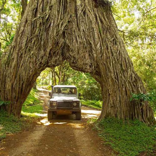
We at Kilemakyaro Mountain Lodge like to offer our guests the opportunity to explore areas off the beaten track, and experience the true beauty, uniqueness and wonder that Africa has to offer.
ARUSHA NATIONAL PARK
Arusha National Park covers Mount Meru, a prominent volcano with an elevation of 4566 m, in the Arusha Region of north eastern Tanzania. The park is small but varied with spectacular landscapes in three distinct areas. In the west, the Meru Crater funnels the Jekukumia River; the peak of Mount Meru lies on its rim. Ngurdoto Crater in the south-east is grassland. The shallow alkaline Momella Lakes in the north-east have varying algal colours and are known for their wading birds.
Mount Meru is the second highest peak in Tanzania after Mount Kilimanjaro, which is just 60 km away and forms a backdrop to views from the park to the east. Arusha National Park lies on a 300-kilometre axis of Africa’s most famous national parks, running from Serengeti and Ngorongoro Crater in the west to Kilimanjaro National Park in the east.
The park is just a few kilometres north east of Arusha, though the main gate is 25 km east of the city. It is also 58 km from Moshi and 35 km from Kilimanjaro International Airport (KIA).
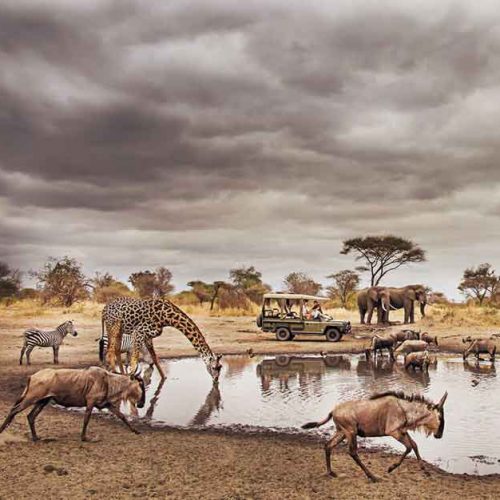
Arusha National Park has a rich variety of wildlife, but visitors shouldn’t expect the same game-viewing experience they find in other national parks of Tanzania’s northern circuit. Despite the small size of the park, common animals include giraffe, Cape buffalo, zebra, warthog, the black-and-white colobus monkey, the blue monkey, flamingo, elephant, bushbuck and many other African animals. Leopard populations are present, but rarely seen. Birdlife in the forest is prolific, with many forest species more easily seen here than elsewhere on the tourist route – Narina trogon and bar-tailed trogon are both possible highlights for visiting birders, whilst the range of starling species provide somewhat less gaudy interest.
Wake up and refresh with a morning Yoga session and breakfast. After breakfast your guide will export you to Arusha National Park here you will enjoy a morning walking safari escorted by a National Armed Ranger and hike along beside animals like giraffes, buffaloes and many other antelopes.
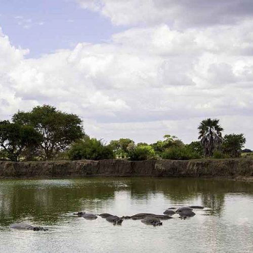
Lunch at the shore of Momela Lake, which is in the middle of the National Park, overlooking hippos and flamingos. After lunch you will enjoy a full game drive in the park, afterwards you drive back to lodge for evening yoga, dinner, and bonfire.
LAKE MANYARA NATIONAL PARK
Lake Manyara National Park is a protected area in Tanzania’s Arusha and Manyara Regions, situated between Lake Manyara and the Great Rift Valley. It is administered by the Tanzania National Parks Authority, and covers an area of 325 km2 (125 sq m) including about 230 km2 (89 sq mi) lake surface. More than 350 bird species have been observed on the lake.
The Park is located 126 km (78 mi) south west of Arusha and can be reached by car in an hour and a half. The park can also be reached from Babati the capital of Manyara Region. Lake Manyara Airport is nearby. To the south, situated on the escarpment above the park, is the 35,399 ha Marang Forest Reserve. To the east is the Kwa Kuchinja Wildlife Migration corridor, which allows wildlife to migrate between the near-by Tarangire National Park to the southeast, Lake Manyara to the west, and the Engaruka Basin to the north. Within the Kwa Kuchinja corridor are several villages. Further from the lake and outside of village land is the 45,000-acre Manyara Ranch, a former livestock ranch, managed by the Tanzania Land Conservation Trust since 2001 and an important part of the corridor allowing wildlife movement between Tarangire and Lake Manyara national parks.
Lake Manyara National Park is part of the Lake Manyara Biosphere Reserve. Lake Manyara, including the areas within and outside the national park, along with the Marang Forest Reserve on the adjacent uplands are included in the Lake Manyara Important Bird Area.
Lake Manyara is a shallow alkaline lake at an altitude of 960 m (3,150 ft), formed in a depression in the Rift Valley System. When full, the lake is a maximum of 10 ft (3.0 m) deep and covers two-thirds of the park. The lake has no outflow, but is fed by underground springs and by several permanent streams that drain surrounding Ngorongoro Highlands. The lake’s depth and the area it covers fluctuates significantly. In extreme dry periods the surface area of the lake shrinks as the waters evaporate and at times the lake has dried up completely. In 2010, a bathymetry survey showed the lake to have an average depth 0.81 m (2 ft 8 in), and a maximum depth of about 1.18 m (3 ft 10 in). At its maximum during the wet season, the lake is 40 km (25 mi) wide by 15 km (9.3 mi) with a maximum depth of 3.7 m (12 ft).
Beside the lake are extensive marshlands, saline flats (that expand in the dry season as the surface area of the lake shrinks) and a grassy floodplain. At the area near the park gate there is a tall forest, sustained by groundwater, dominated by evergreen fig and mahogany trees. On the west side of the park, the rocky escarpment of the rift valley wall rises steeply to 1,219–1,829 m (3,999–6,001 ft). Large African baobab trees (Adansonia digitata) are scattered on the slopes. A narrow zone of dense acacia woodland grows at the base of the rift wall, on materials washed down the face.
Other features include a hippopotamus pool at the northern end of the lake and two hot springs, one near the centre of the park and the other near the southern edge. There is a hot water spring on the western shores of lake Manyara called Maji Moto hot water springs. This 60 °C geothermal feature is formed by underground water that passes through hot volcanic magma rocks of the great rift valley.
NGORONGORO CRATER
The Ngorongoro Conservation Area is a protected area and a UNESCO World Heritage Site located in Ngorongoro District, 180 km (110 mi) west of Arusha City in Arusha Region, within the Crater Highlands geological area of northern Tanzania. The area is named after Ngorongoro Crater, a large volcanic caldera within the area. The conservation area is administered by the Ngorongoro Conservation Area Authority, an arm of the Tanzanian government, and its boundaries follow the boundary of the Ngorongoro District in Arusha Region. The western portion of the park abuts the Serengeti National Park (also a UNESCO World Heritage Site), and the area comprising the two parks and Kenya’s Maasai Mara game reserve is home to Great Migration, a massive annual migration of millions of wildebeest, zebras, gazelles, and other animals. The conservation area also contains Olduvai Gorge, one of the most important paleoanthropological sites in the world.
The 2009 Ngorongoro Wildlife Conservation Act placed new restrictions on human settlement and subsistence farming in the Crater, displacing Maasai pastoralists, most of whom had been relocated to Ngorongoro from their ancestral lands to the north when the British colonial government established Serengeti National Park in 1959.
The Pliocene Ngorongoro volcanic group consists of eight extinct shield volcanoes within the Eyasi half-graben, the eastern boundary marked by the Gregory Rift Western Escarpment. The Lake Eyasi escarpment bounds the half-graben on the southwest. Within the complex, five volcanoes are dome-shaped cones, while three have calderas. Ngorongoro Volcano (2.5–1.9 Ma) is primarily basaltic trachyandesite. The caldera is fed by the Munge and Oljoro Nyuki Rivers, while the Ngoitokitok hot springs feed into the Goringop swamp. Lake Magadi is a shallow (1.7 m) alkaline lake. Other volcanoes within the complex include Olmoti (2.01–1.79 Ma), Empakaai, Loolmalasin, Sadiman (3.7 Ma), Lemagrut, and Oldeani. The northwest portion of the conservation area consists of the Serengeti Plains, the Salei Plains, the Oldupai Gorge, and the Gol Mountains inselbergs. These inselbergs are part of the Mozambique Belt quartzite and mica schist about (800–500 Ma) in age.
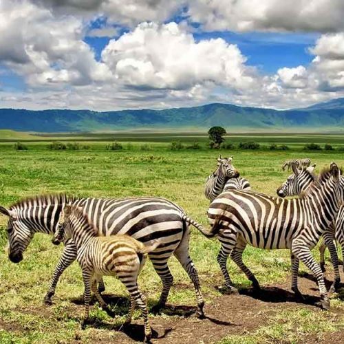
Approximately 25,000 large animals, mostly ungulates, live in the crater. Large mammals in the crater include the black rhinoceros (Diceros bicornis michaeli), the local population of which declined from about 108 in 1964-66 to between 11–14 in 1995, the African buffalo or Cape buffalo (Syncerus caffer), and the hippopotamus (Hippopotamus amphibius). There also are many other ungulates: the blue wildebeest (Connochaetes taurinus) (7,000 estimated in 1994), Grant’s zebra (Equus quagga boehmi) (4,000), the eland (Taurotragus oryx), and Grant’s (Nanger granti) and Thomson’s gazelles (Eudorcas thomsonii) (3,000). Waterbucks (Kobus ellipsiprymnus) occur mainly near Lerai Forest.
Since 1986, the crater’s wildebeest population has fallen from 14,677 to 7,250 (2003-2005). The numbers of eland and Thomson’s gazelle also have declined while the buffalo population has increased greatly, probably due to the long prevention of fire which favors high-fibrous grasses over shorter, less fibrous types.
Lake Magadi, a large lake in the southwest of the crater, is often inhabited by thousands of mainly lesser flamingoes.
Located in the Rift Valley, the Ngorongoro Crater is the largest unflooded and unbroken caldera in the world. Approximately 20km’s across, 600m’s deep and 300sq km’s in area, the Ngorongoro Crater is a breathtaking natural wonder.
We’ll book your stay at our sister Lodge at Enyati Lodge situated in Karatu, Ngorongoro Area, about 45min drive to Ngorongoro crater gate.
TARANGIRE NATIONAL PARK
Tarangire National Park is a national park in Tanzania’s Manyara Region. The name of the park originates from the Tarangire River that crosses the park. The Tarangire River is the primary source of fresh water for wild animals in the Tarangire Ecosystem during the annual dry season. The Tarangire Ecosystem is defined by the long-distance migration of wildebeest and zebras. During the dry season thousands of animals concentrate in Tarangire National Park from the surrounding wet-season dispersal and calving areas.
It covers an area of approximately 2,850 square kilometers (1,100 square miles.) The landscape is composed of granitic ridges, river valley, and swamps. Vegetation is a mix of Acacia woodland, Combretum woodland, seasonally flooded grassland, and baobab trees.
The park is famous for its high density of elephants and baobab trees. Visitors to the park in the June to November dry season can expect to see large herds of thousands of zebra, wildebeest and cape buffalo. Other common resident animals include waterbuck, giraffe, dik dik, impala, eland, Grant’s gazelle, vervet monkey, banded mongoose, and olive baboon. Predators in Tarangire include lion, leopard, cheetah, caracal, honey badger, and African wild dog.
The oldest known elephant to give birth to twins is found in Tarangire. A recent birth of elephant twins in the Tarangire National Park of Tanzania is a great example of how the birth of these two healthy and thriving twins can beat the odds.
Home to more than 550 bird species, the park is a haven for bird enthusiasts. The park is also famous for the termite mounds that dot the landscape. Those that have been abandoned are often home to dwarf mongoose. In 2015, a giraffe that is white due to leucism was spotted in the park. Wildlife research is focused on African bush elephant and Masai giraffe.
Since 2005, the protected area is considered a Lion Conservation Unit.Tarangire National Park can be reached via paved road south from Arusha in under two hours. Lake Manyara National Park is a 70 kilometer (43 mile) drive from Tarangire. The wonder of this National Park lies in its large elephant herds. In the dry season the Tarangire River is the only source of water in the area, and all the game depend on this river.
SERENGETI NATIONAL PARK
The Serengeti National Park is a large national park in northern Tanzania that stretches over 14,763 km2 (5,700 sq mi).[1] It is located entirely in eastern Mara Region and north east portion of Simiyu Region and contains over 1,500,000 hectares (3,700,000 acres) of virgin savanna. The park was established in 1940.
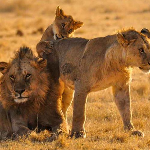
The Serengeti is well known for the largest annual animal migration in the world of over 1.5 million blue wildebeest and 250,000 zebra along with smaller herds of Thomas’ Gazelle and eland. The national park is also home to the largest lion population in Africa. It is under threat from deforestation, population growth and ranching.
Serengeti National Park forms a Lion Conservation Unit since 2005 together with Maasai Mara National Reserve. More than 3,000 lions live in this ecosystem. The population density of the African leopard is estimated at 5.41 individuals per 100 km2 (39 sq mi) in the dry season.
African bush elephant herds recovered from a population low in the 1980s caused by poaching, and numbered over 5,000 individuals by 2014. The African buffalo population declined between 1976 and 1996 due to poaching, but increased to 28,524 individuals by 2008. The black rhinoceros population was reduced to about 10 individuals in the 1980s due to poaching, and less than 70 individuals survive in the park today. Rhinos mostly browse on grasses, woody Indigofera, Acacia and Crotalaria forbs and shrubs.
Other mammal carnivores include the Cheetah, about 3,500 spotted hyena, Black-backed jackal, African golden wolf, honey badger, striped hyena, caracal, serval, banded mongoose, and two species of otters.[citation needed] The African wild dog was reintroduced to the area in 2012 after disappearing in 1991. Other mammals include hippopotamus, common warthog, aardvark, aardwolf, African wildcat, African civet, common genet, zorilla, african striped weasel, bat-eared fox, ground pangolin, crested porcupine, three species of hyraxes and cape hare. Primates such as yellow and olive baboons, patas monkeys, and vervet monkey, mantled guereza are also seen in the gallery forests of the Grumeti River.
The great migration is the world’s longest overland migration. The complete migration route is around 800 km (500 mi). South of this migration route covers the Ngorongoro Conservation Area where around half a million Wildebeest are born between January and March. By March, at the beginning of the dry season, roughly 1.5 million and 250,000 zebras start to migrate heading north towards Maasai Mara in Kenya. Common eland, plains zebra, and Thomson’s gazelle join the wildebeest. In April and May, the migrating herds pass through the Western Corridor. To get to the Maasai Mara, the herds have to cross the Grumeti and Mara Rivers where around 3,000 crocodiles lie in wait. For every wildebeest captured by the crocodiles, 50 drown. When the dry season ends in late October, the migrating herds start to head back south. Around 250,000 wildebeests and 30,000 plains zebras die annually from drowning, predation, exhaustion, thirst, or disease.
Southern Circuit
SELOUS GAME RESERVE
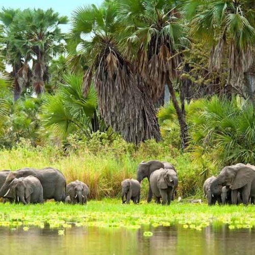
The Selous Game Reserve is a protected area in southern Tanzania. It covers a total area of 50,000 km2 (19,000 sq mi) and has additional buffer zones. It was designated a UNESCO World Heritage Site in 1982 due to its wildlife diversity and undisturbed nature. Some of the diverse wildlife of the miombo include the African bush elephant, south-central black rhinoceros, hippopotamus, lion, African wild dog, African buffalo, Masai giraffe, Plains zebra and Nile crocodile. Permanent human habitation is not permitted within the reserve. All human entry and exit is controlled by the Wildlife Division of the Tanzanian Ministry of Natural Resources and Tourism.
The area was first designated a protected area in 1896 by the German Governor of Tanganyika Hermann von Wissmann, and became a hunting reserve in 1905. The reserve was named after Frederick Selous, a famous big game hunter and early conservationist, who died at Beho Beho in this territory in 1917 while fighting against the Germans during World War I. Scottish explorer and cartographer Keith Johnston had died at Beho Beho in 1879 while leading a Royal Geographical Society expedition to the Great Lakes of Africa with Joseph Thomson.
A boundary change to allow the use of uranium deposits has been approved.[2] The approval for the boundary change was given by the UNESCO and seriously criticized by environmentalists and organizations.
Portions of the Selous may be regarded as untouched wilderness. The Germans never mapped the Rufiji Floodplain, and in 1917, an expedition headed by Lt. E. William Boville described that area as “uninhabitable”.
RUAHA NATIONAL PARK
Ruaha National Park is a national park in Tanzania. The addition of the Usangu Game Reserve and other important wetlands to the park in 2008 increased its size to about 20,226 km2 (7,809 sq mi).
The park is about 130 kilometres (81 mi) west of Iringa. The park is a part of the 45,000 square kilometres (17,000 sq mi) Rungwa-Kizigo-Muhesi ecosystem, which includes the Rungwa Game Reserve, the Kizigo and Muhesi Game Reserves, and the Mbomipa Wildlife Management Area.
The name of the park is derived from the Great Ruaha River, which flows along its southeastern margin and is the focus for game-viewing. The park can be reached by car on a dirt road from Iringa and there are two airstrips – Msembe airstrip at Msembe (park headquarters), and Jongomeru Airstrip, near the Jongomeru Ranger Post.
Germany gazetted the Saba Game Reserve in 1910. British colonial authorities changed the name to the Rungwa Game Reserve in 1946.In 1964, the southern portion of the reserve was excised and elevated to full park status.
More than 571 species of birds have been identified in the park. Among the resident species are hornbills. Many migratory birds visit the park.
Other noted animals found in this park are East African cheetah and lion, African leopard and wild dog, spotted hyena, giraffe, hippopotamus, African buffalo, and sable antelope.
Since 2005, the protected area is considered a Lion Conservation Unit. The park was formerly known for its large elephant population. It had numbered 34,000 in the Ruaha-Rungwa ecosystem in 2009, before declining to only 15,836, plus or minus 4,759, in 2015.
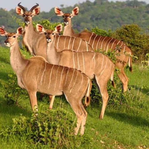
We will spend our days searching the forest and plains for rare antelopes such as greater Kudu, Roan and Sable antelope.
MIKUMI NATIONAL PARK
Mikumi National Park is a national park near Morogoro, Tanzania with an area of 3,230 km2 (1,250 sq mi) that was established in 1964. It is the fourth largest in the country. The park is crossed by Tanzania’s A-7 highway.
Mikumi National Park borders Selous Game Reserve on the south, the two areas forming a unique ecosystem. Two other natural areas bordering the national park are the Udzungwa Mountains and Uluguru Mountains. Malundwe Mountain is within the park, the highest of a belt of hills that run east and west through the park, connecting the Uluguru Mountains to the northeast with the Uvidunda and Udzungwa mountains to the west. Malundwe Mountain consists of three peaks along a ridge running north and south. Malundwe’s south peak is the highest point in the park, reaching 1290 meters elevation.
The landscape of Mikumi is often compared to that of the Serengeti. The road that crosses the park divides it into two areas with partially distinct environments. The area north-west is characterized by the alluvial plain of the river basin Mkata. The vegetation of this area consists of savannah dotted with acacia, baobab, tamarinds, and some rare palm. In this area, at the furthest from the road, there are spectacular rock formations of the mountains Rubeho and Uluguru. The southeast part of the park is less rich in wildlife, and not very accessible.
The fauna includes many species characteristic of the African savannah. The park contains a subspecies of giraffe that biologists consider the link between the Masai giraffe and the reticulated giraffe. Other animals in the park are elephants, zebras, impala, eland, kudu, black antelope, baboons, wildebeests and buffaloes. At about 5 km from the north of the park, there are two artificial pools inhabited by hippos. More than 400 different species of birds also inhabit the park.Mikumi National Park is about 3230 sq. km (1247 sq. miles) and is home to an abundance of wildlife.
The landscape is dominated by the flood plain of the river Mkata which forms flat, open grasslands.